
|
|
#1
 09-06-2011, 09:19 PM
|
|||
|
|||
|
Despite rough seas for the evening of 9-3, I became one of a four guy team to hop on my neighbor's 42 foot lobster boat in Rhode Island. The plan was to steam out to Block Island for a night at the Strippers club...not what you're thinking, I said strippers!
 Long story short, slow pick at the big ones, we caught 19 strippers in the mid 30 lbs range with one tipping at 47lbs for my new personal best. All fish were caught on live eels, set on a 7/0 hooks and 6 foot fluorocarbon leaders on a 10 oz slidding rig. Awesome night out with a new (to me) group of guys. Besides us, there was another small boat ou there too, in the rough cathing big strippers, their boat was a very stable 21 footer w/ a 200 hp four stroker. I wished my V20 was that stable. Here's a pic of my 47 lbs stripper; 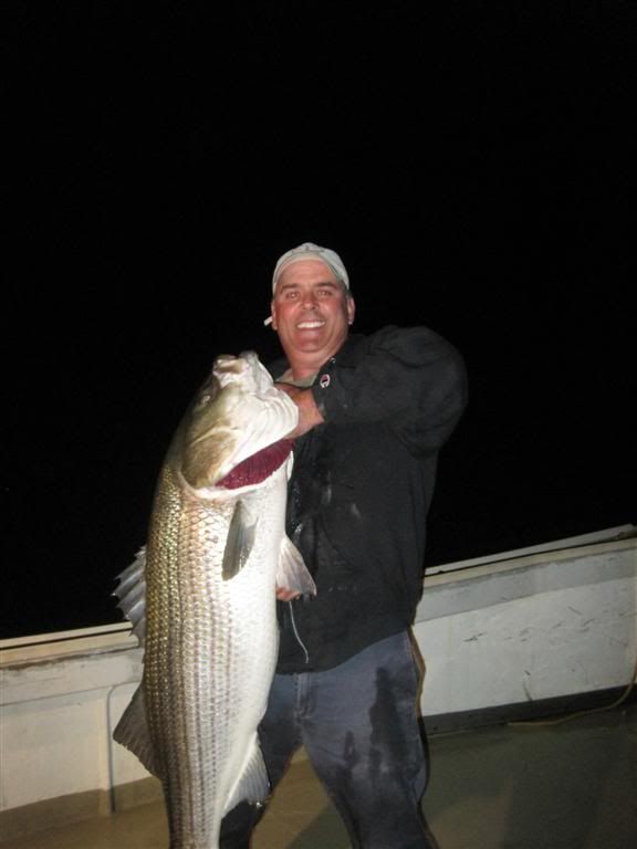
__________________
Life is composed of a bunch of little nothings! Sea Ray 19.5 I/O 351 Cleveland - SOLD 1989 V20 CC 1998 150 Ocean Runner - SOLD 
|
|
#2
09-06-2011, 09:26 PM
|
||||
|
||||
|
Nice beast there cant wait for them to get here. Congrats
__________________
1987 Dual Console / 2007 200 hp E-Tec 
|
|
#3
09-06-2011, 10:25 PM
|
||||
|
||||
|
Very nice

__________________
Willy 1986 V20 Old School 1992 V20 1992 150 Yamaha 1997 HydraSport 2250 Vector 2009 17' G3 Outfitter "G Spot" http://www.youtube.com/watch?v=TDebw...eature=related "I won't be wronged, I won't be insulted and I won't be laid on a hand on. I don't do these things to others and I require the same from them" JW
|
|
#4
09-06-2011, 11:38 PM
|
||||
|
||||
|
Nice fish, but I have to be honest it was the word striPPers in the title that got my attention.
__________________
2011 SUNDANCE B20CCR SKIFF, 2011 YAMAHA 90HP 4 STROKE, 2011 KARAVAN SINGLE AXLE ALUMINUM TRAILER, LOWRANCE ELITE-7 HDI, MINN KOTA RIPTIDE TROLLING MOTOR 2000CC HYDRA-SPORT 225+HP EVINRUDE SOLD  AND THE PINK JEEP!!!! R.I.P. http://www.wellcraftv20.com/communit...ad.php?t=11664 
|
|
#6
09-07-2011, 08:01 AM
|
|||
|
|||
|
Nice catch! We fish the Block at night and it's a blast. Same set-ups you used and we catch quite a few good size ones also. Were you guys fishing the "Peanut" on the Southwest Ledge? We fish there in my V20 between the Block & Montauk. Gets rough but the V handles it pretty darn good. At night it gets hairy when there are alot of boats out there drifting, but it's managable. Gotta love the Block!
__________________
1976 Wellcraft V-20 Steplift w/1983 175 HP Johnson 1973 Sears 12 ft. V bottom w/1958 3 HP Evinrude "A boat is a hole in the water, surrounded by wood & fiberglass, into which one pours hard earned money into"
|
|
#7
09-07-2011, 12:44 PM
|
||||
|
||||
|
What a pig. Congratulations!
__________________
 1994 Wellcraft V21
|
|
#8
09-07-2011, 07:18 PM
|
|||
|
|||
|
Quote:
 Shawsee, it was my second time there, so I'm not realy sure if the spot we fished is called the "peanut". About a month ago, my son Bryan and I fished the area at night for the first time ever! NBS. All we got were bluefish bite offs. I don't know about you Vee, but mine rocks while drifting...a bite more than I'd like to admit, I don't know if its because of the T-top or what. All I know is that there's no way in heck I would be there last Sat with my Vee, the little boat (20's) I refer to was like a little cork all over those huge waves, those guys bounced like crazy, but their boat rocked much less tht my Vee does. Can't wait to get a chance to go there again, fish for black sea bass during the day and stay well into the dark for the cow bass...on my Vee that is. 
__________________
Life is composed of a bunch of little nothings! Sea Ray 19.5 I/O 351 Cleveland - SOLD 1989 V20 CC 1998 150 Ocean Runner - SOLD
|
|
#9
09-07-2011, 08:44 PM
|
|||
|
|||
|
Quote:
The "peanut" is a peanut shape rock ledge that comes up to 30 feet from 60 plus depth. If you have a gps chartplotter you can locate it easy enough. It's right off of the Southwest Ledge on the southwest side of Block between the two red cans. It's close to the 3-mile limit area and between Block & Montauk. We got hit bad by blues there also two weeks ago. We were trolling niners and the blues were chewing up the plastics pretty bad where we had to switch over to snapping parachute jigs on wire. Caught some monster ocean blues close to twenty five pounders but no stripers. I pick my days to be venturing out there between Block & Montauk. Sometimes it does get real nasty out there real quick too. My V does great drifting and she does rock somewhat but not that bad at all. I will attach a great link for you ok? It's the NOAA link to the red buoy on the Southwest corner of Block. Great wave info to check on the morning or night you are ready to head out. When Irene hit Sunday that buoy was rocking at 27.6 feet at 12 second intervals. Waves were 27 feet high and 10 second intervals. Simply incredible info site and a great source of info right here. Great to see you again neighbor! http://www.ndbc.noaa.gov/mobile/stat...?station=44097
__________________
1976 Wellcraft V-20 Steplift w/1983 175 HP Johnson 1973 Sears 12 ft. V bottom w/1958 3 HP Evinrude "A boat is a hole in the water, surrounded by wood & fiberglass, into which one pours hard earned money into"
|
|
#10
09-08-2011, 07:58 AM
|
||||
|
||||
|
Now THAT's a fish!!!
Man, I need to get out and give it a try soon. Been so busy...next available day for me would be 9/17... But I can't complain, got my health and I am not flooded... rkc
__________________
Sorry to say that I no longer have a 1984 V20 :(
|
 |
|
|


 Linear Mode

