
|
|
#1
 09-19-2007, 01:08 PM
|
||||
|
||||
|
well the boss has a vacation house in reedville, va on the chesapeake bay. we are going fishing there in october, and i am taking my boat. it is a 5 hour drive from here and I dont want to haul the old girl that far.
So my question is...... can I do any of these courses??? I figured you would be the one to know ;) How long do you think it would take at 30 mph on a calm day??? 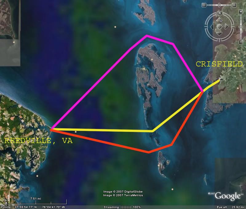
__________________
 CY 1984 V20 STEP LIFT I/O 470 MERCRUISER Wheeling, WV CY 1984 V20 STEP LIFT I/O 470 MERCRUISER Wheeling, WV

|
|
#2
09-19-2007, 01:57 PM
|
||||
|
||||
|
My baycharts are in the boat. The northern route you drew is the longest and safest. The two southern routes may be real iffy, lots of stumps if I can recall.
I'd probably go through smith island, the Thorofair as it is called. After looking, I'll have to check my charts. I think the yellow line may be doable. I'd say no more than an hour at cruise. 'Slot ps I hope to be fishing that area Friday or Sunday pps How the he!! did you do that?
__________________
Airslot Airslot's V-20 Gallery
|
|
#3
09-19-2007, 03:05 PM
|
||||
|
||||
|
That is a Google Earth image and the lines and text were added in photoshop. ;D
So you think I can run the yellow line till i get close to the island, weave through the shallows, and then full speed again on the west side of the island???
__________________
CY 1984 V20 STEP LIFT I/O 470 MERCRUISER Wheeling, WV
|
|
#4
09-19-2007, 03:07 PM
|
||||
|
||||
|
I'll bet it was screen dump and then Power Point.
There is a great little program I found for free, called FastStone Capture. If you guys want it I'll e-mail it to ya.
__________________
  Bottom's up!!! Bottom's up!!!
|
|
#6
09-19-2007, 03:23 PM
|
||||
|
||||
|
Yellow line is doable pending the shallows 'tween Smith and Tangier. High tide would help.
__________________
Airslot Airslot's V-20 Gallery
|
|
#8
09-19-2007, 04:42 PM
|
||||
|
||||
|
It's definately feet, but 2-5 on average I'd say? I'm pretty sure that you can get across there. My buddy Matt fishes there all the time, I''l ask him about it tonight.
'Slot
__________________
Airslot Airslot's V-20 Gallery
|
|
#10
09-20-2007, 11:32 AM
|
||||
|
||||
|
Well just checked the tide charts......and it looks like I will be trying this run at LOW tide......crap >:(
__________________
CY 1984 V20 STEP LIFT I/O 470 MERCRUISER Wheeling, WV
|
 |
| Thread Tools | |
| Display Modes | |
|
|


 Linear Mode

