
|
|
|
|
#1
|
||||
|
||||
|
First I took this net that used to be in the back of my Durango and attached it to the starboard side bulkhead in the cabin.
 Then I made this mount for my hand held gps.  The wires run through a hole under the mount that was there from a previous owner and into will go into a lighter socket that I have not yet installed behind the dash  In the links section of this site you can find a link to maptech. www.maptech.com I downloaded a chart and then created a mark at all the markers and other obstructions and hazards. Then I downloaded the marks into the gps. While I don't have a map in the gps, I do have the local markers. Makes getting home at night a lot easier
__________________
Formerly - 89 cuddy 165hp I/O and 95 V21 / 150 Honda When the people fear their government, there is tyranny; when the government fears the people, there is liberty. - Thomas Jefferson Last edited by rb437; 04-22-2008 at 09:49 PM. 
|
|
#2
 04-23-2008, 04:28 AM
|
||||
|
||||
|
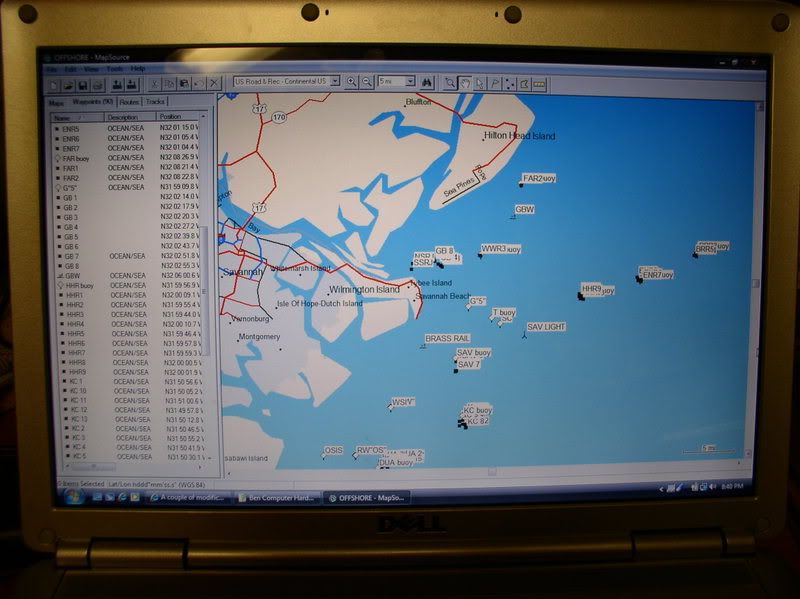
I've got Garmins Mapsource and the same GPS.
It will let me transfer waypoints to and from the Gps and computer. But I can only transfer tracks from the GPS to the computer. Best thing about it is the ability to pull the curser to any location on tracks or anything else and the lat&lon numbers are there. Thanks for posting it in "Links", in case I have problems with mine. Thought I had lost the ability to use mine after getting a new computer. The adaptor had a 9pin connector, whereas my computer only had USB connections. Found the adaptor-adaptor at Radio Shack.
__________________
 '75 Cuddy with '00 Johnson Ocean Pro 150 horse Benny Last edited by tsubaki; 04-23-2008 at 04:56 AM.
|
|
#3
04-23-2008, 07:32 PM
|
||||
|
||||
|
Using the online charts you can also create a route and download it to the gps. I have not been able to download a track to the online charts though. i find the ability to take a mark from the online chart and load it into the gps real handy. The approach to my slip is hard to see at night and being able to steer to a mark really helps.
__________________
Formerly - 89 cuddy 165hp I/O and 95 V21 / 150 Honda When the people fear their government, there is tyranny; when the government fears the people, there is liberty. - Thomas Jefferson
|
|
#4
04-23-2008, 07:46 PM
|
||||
|
||||
|
This is what the old Garmin looked like.
 No real maps, but you can enter locations and symbols then they display in the location. One negetive part is, when downloading to the computer it won't overlay onto another file. Each entry will be a seperate file.
__________________
'75 Cuddy with '00 Johnson Ocean Pro 150 horse Benny
|
 |
|
|


 Hybrid Mode
